As of this writing on July 31st, there are currently three intriguing weather events unfolding across the United States that are excellent examples of what a world in the age of human caused climate change looks like. I will explain what is happening and how this all relates back to a changing climate.
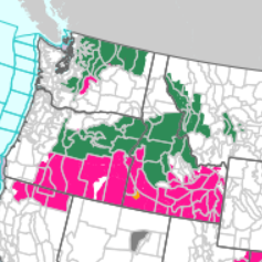
Area 1: Pacific Northwest
An area of scattered slow moving storms is beginning to unfold across the Pacific Northwest. Predominantly in two large areas: the Cascades of Washington and the interior Northwest from central Oregon towards the Salmon River basin in Idaho. This part of the world does not see thunderstorms very often due to its cool stable climate most of the year. However, when they do it brings a dual threat that has become inreasingly more common as the years go on.
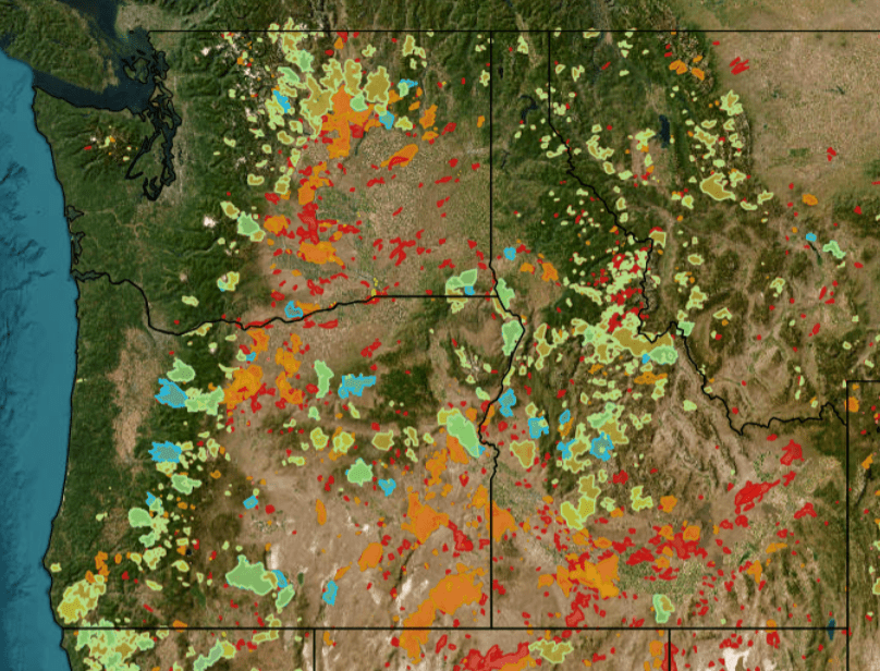
The Pacific Northwest has in recent years become ravaged by frequent wildfires. Below is a burn scar map of fires just since 2010. It is now becoming harder to find a healthy unburned forest. This region is nearly void of flash flooding due to the thick vegetation that efficiently absorbs the frequent precipitation. However, when a wildfire burns through this vegetation it leaves the steep slopes of the Cascades or northern Rockies vulnerable. There is no longer vegetation to absorb that moisture, when heavy rain does occur it now washes down the slopes becoming a torrent of debris and mud that is destructive and deadly to those in the path.
These flash flood watches are in effect to warn people of these burn scars flooding if a slow moving storm drops heavy rain over that area. To make matters even worse, the scattered nature of these storms means not everywhere will see rain and Washington is entering a drought. Lightning accompanying these storms could spark new wildfires where the rain is lighter or doesn’t fall. These new fires will make new burn scars.
Thus creating a vicious cycle, a wildfire burns, it rains, the scar floods, the lightning starts new fires that create new burn scars that will then flood when the next heavy rain falls. And the only way to stop this cycle is for the forest to regrow, but the heavy rain washes away the topsoil taking new seeds or seedlings with it. This means it will take longer for the forest to regenerate if it does grow back at all. The longer the burn scar goes without new vegetation the less chance it has to recover. This right here, is what keeps me up at night.
Area 2: Ruidoso, NM
The small mountain town of Ruidoso, NM is a terrifying example of this very scenario. Ruidoso, NM sits high in the Sacramento Mountains in southern New Mexico among thick stands of ponderosa pines. In June of 2024, a wildfire burned a large area in the slopes above the westside of town. Heroically, the firefighters were able to stop it from reaching town. The townspeople of Ruidoso were not out of the woods however. In summer these mountains receive nearly daily afternoon thunderstorms as do many parts of the Rockies and Desert Southwest.
On July 8, 2025, the inevitable happened. As Kerrville, TX searched for those missing from the devastating flash floods there, another very intense rainstorm started on the burn scar in Ruidoso. The rain caused a literal wall of mud and debris crashing into town. Taking homes along with it and killing 3 people. This was not the end for Ruidoso. Since July 8th, there have been 8 more flash floods on 8 different days. And then today, July 31st at 12:23pm MDT they issued their 10th flash flood warning since July 8th. 10 flash floods on 10 different days in just 3 weeks time. How do you even live like that? The streets are buried in feet of mud. Homes and businesses are devastated and their summer tourism is non existant. Insurance claims don’t even have time to be processed before the next flood comes crashing down the mountain. There really is no end in sight for this to stop for likely years to come.
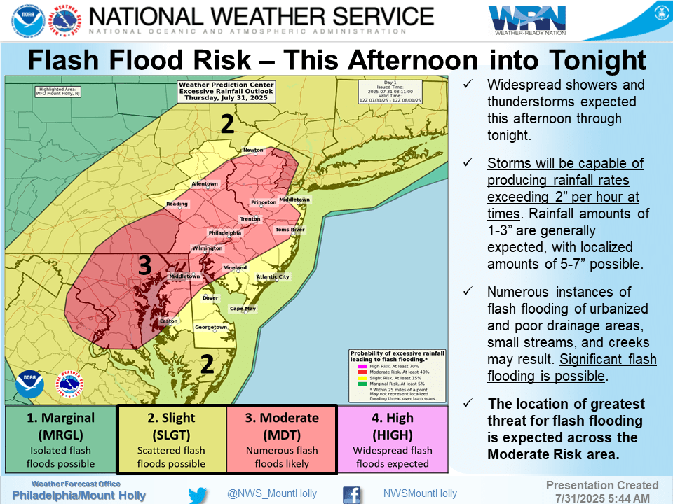
Area 3: Mid Atlantic Corridor
The final area is another spot reeling from recent flash flooding and is currently under new flash flood warnings as I type this. The corridor from New York City to Washington D.C. is experiencing intense training thunderstorms. Training thunderstorms are when storms move over the same area repeatedly due to a stationary or slow moving front. This isn’t always a huge deal, but when you combine the intense heat and humidity they are experiencing this makes these storms extremely effiecient rain producers sometimes dumping 2+ inches of rain in just an hour’s time.
As of this writing there are flash flood warnings for most of the NYC metro (Manhattan, Newark, western Long Island) nearly all of the I-5 corridor in New Jersey including all of Philadelphia and Wilmington, DE. There are also flash flood warnings for metro Baltimore and Washington D.C. In these scenarios it is not burn scars that are the issue but concrete and urban enviornments. Even with storm drains and manmade drainages, when the rain falls hard enough it can’t get rid of it fast enough leading to flooded roadways, homes, businesses, and even subways. This is coming just days after NYC and NJ experienced intense flash flooding from a similar pattern.
How this Relates to Climate Change?
I would like to preface this by saying that not every single weather event is because of climate change. However, a lot of events can be linked to our changing climate. Essentially the thing to take away from human caused climate change is that it is happening extremely fast. Yes, the climate is always changing but in spans of thousands of years, not decades. It is too fast for plants, animals, or people to adapt. Thousands of years of slow change, sure that’s enough time for living organisms to adapt, but a 4C increase between 1900 and 2100, that is like being flash fried.
Having said that, what we can expect from a warming world is two things: 1) a weaker, more erratic jet stream and 2) more heat and moisture in the atmosphere. A weaker more erratic jet stream leads to two very different scenarios.
The first being a weaker jet stream, especially in summer since that is when the jet stream is seasonably the weakest. This means weather patterns will essentially get stuck. The jet stream keeps weather systems moving across the Earth, but a weaker jet stream means systems either take longer to move out or get stuck completely. This creates a scenario where a rainy day becomes a rainy week or a month of dry weather becomes six months of dry weather. You start to feel like you are bouncing from one extreme to the next. A drought to a flood and back again. A striking example is Kerrville, TX, they went from a D4 “exceptional” drought (the highest rating) on July 1st to almost a year’s worth of rain in just a few hours on July 4th.
The second is an erratic jet stream. This type of situation is more common during the equinoxes or in winter. This is when you start to get the more extreme or unusual weather patterns. An EF-4 tornado in Kentucky in December 2021, the Hurricane that hit California in 2023, or the Great Freeze in Texas in February 2021 are good examples. This could be a seasonal event that is just more intense than usual or an event happening in a place that usually doesn’t experience this type of weather. It could be a lack of usual weather or too much benign weather, it doesn’t always have to be a destructive event.
This leaves you to the warming part of the equation. A warmer atmosphere means a higher likelihood of both droughts and floods. Droughts because prolonged heat waves dry out soil and plants quicker which leads to a higher fire danger. Warmer winter temperatures means winter starting later, ending earlier, leading to less snow that ends up melting faster in spring. A slow snowmelt is neccessary for wildfire mitigation, drought alleviation, and for water supplies for much of the West. On the opposite end, warmer temperatures mean more moisture which means when it rains it rains harder and for longer.
I will leave you with this, there has always been shocking and unusual weather events. However, the frequency and intensity of these events is undeniable. 2025 is already the costliest year ever in the U.S. for natural disasters (CPI adjusted) and we haven’t really even gotten into hurricane season yet. The wildfire burning on the north rim of the Grand Canyon is the 10th largest fire in Arizona history as of yesterday. All 10 occurred after the year 2000 (most after 2015), it is hard to think there was not one fire prior to 2000 that was big enough to make the list, not even one. They happened in the past but they were not as frequent or intense.

Leave a comment